Friday, August 31, 2012

Once In A Blue Moon

Tonight we were lucky enough to get out to paddle under the second full moon of the month, a Blue Moon. There are two considerations for Blue Moons: Seasonal, where there are four full moons in a season (or quarter); and calendar, when two full moons occur in the same month. This month, it's a calendar Blue Moon and we won't see another like it until July 2015. 
(Please forgive the grainy images, my waterproof camera isn't the best with night photography)

Reflection on the Water
Moon Beginning to Rise Before the Sunset
Windwaves and Sunset
It's also Harbor Days this weekend in Olympia and tugboats from all over the Sound have come to visit and race here. I'm hoping to get out during some of the racing on Sunday and surf some of the wake these tugs can throw. I'm also excited to see the Virginia V here, 125 foot ferry boat built in 1921-22. An original member of the Mosquito Fleet, long before Washington had it's own ferry system, the Virginia V used to run between Seattle and Tacoma before WWII. During the war, she was enlisted as a troop ship, shuttling men between forts in the north Sound. Afterwards, her career took a brief downturn, running between Portland and Astoria on the Columbia River and then again on the Puget Sound. After 1950, when Washington invested in its own ferry transportation, she became a backwater excursion boat, until 1976 when the Virginia V Foundation was formed and received grants and funds to purchase her for $126K and refurbish her. Today the Virginia V provides public excursions, hosts private parties, visits maritime festivals, and even functions as Seattle's Lake Union floating farm boat! Tours are available while she's here this weekend.
Virginia V at night

Wednesday, August 29, 2012

South Sound Paddles; Boston Harbor to Gull Harbor

Boston Harbor to Gull Harbor
This is a nice and easy paddle, following the shoreline southward and back. After passing Burfoot Park, you're rewarded with a relatively private harbor, likely all to yourself. I often see waterfowl there, including eagles, kingfishers, guillemots, surf scoters, and herons. The only concerns on this paddle are weather (wind from the south, west, or north) and tidal exchanges as you enter and exit the narrow entrance to the harbor. Strong tidal currents can create extremely swift currents at the mouth of the harbor, which may be challenging to less experienced paddlers.
Round trip, the distance is roughly 4.5 Nautical miles


The boat launch at Boston Harbor
Abandoned waterfront property along the route
Gull Harbor
The cliffs and entrance to Gull Harbor on the right

This Morning...


Just one of those beautiful late summer (or early fall?) mornings that makes that early alarm worth it. 
A few photos...

Sunrise
Someone's Homemade Hazard Buoy Attached to...
...this Deadhead Piling near the Channel
Beautiful 'Red Jacket' Visting the Port
Calling Something 'Classy' Usually Means It Isn't

Sunday, August 26, 2012

Poseidon's Finishing School for Stand Up Paddlers

Sorry for the brief hiatus but I've been a little busy...


But I can now proudly say "It's official!" After years of taking friends, coworkers, and acquaintences out stand up paddling, I've finally, officially launched my stand up paddling endeavor. I really enjoy introducing beginners to the sport and to the water. But even more, I love coaching paddlers who have already fallen in love with stand up paddling and want to realize their paddling potential. That is why coaching is a large part of what I hope to do. Custom training plans, a focus on paddling techniques, and increasing water-based knowledge are some of the ways I plan on helping paddlers become more comfortable with the Sound. 

My bigger goal, now no longer a secret, is to help people fall in love with paddling and the coastal marine environment, because we tend to protect what we love. And the Salish Sea could use a lot more love...
Please check out my website at www.schoolofsup.com

Tuesday, August 21, 2012

Visualization


For me, I paddle well when I use visualization  for the various aspects of my paddling technique. I hope that some of these may help you...

Holding the Paddle - When I hold the paddle, I imagine holding an inflatable Fit Ball inside the circle that includes my arms, hands, chest, and paddle. I imagine Chi energy flowing through that impenetrable and unbreakable circle. It helps me as I both set and pull the paddle, as well as with stroke recovery.


Reach - I focus on pulling the shoulder blade of my top hand back and around to the opposite side of the board. Instead of simply reaching forward with the lower hand, pulling the top hand's shoulder blade back allows you to reach even further. Try it, you'll see what I mean.


Setting the Paddle - I imagine Olympic divers entering the water with no splash. That's what you want with your paddle, a clean entry that 'grabs' the water.

Pull - After you set the paddle and grab a chunk of water, you are essentially pulling yourself, and your board, to where you set your paddle. You aren't moving the paddle through the water. I often imagine a long row of poles in front of me and I reach and pull myself and my board from one to the next. A lot like Tarzan swinging on vines, only I'm gliding from one paddle's pole to the next.

Recovery - I think of a medieval swordsman pulling his sword from its sheath. Using the lower hand, I twist outward and pull the paddle from the water, just enough for it to clear the water and move forward for the next stroke. The top hand merely functions as support and a guide.

Cadence & Timing - I often use a cadence that I've heard Danny Ching (winner of numerous outrigger and stand-up paddle events) uses, just like a waltz, 1, 2, 3, and... 1, 2, 3, and... with the recovery on 'and...' I'll also often use the mantra "Pull hard, pull often" to keep a steady rhythm while paddling.

I hope these are helpful. I'll share more in a later post...


Monday, August 20, 2012

Water Highways

Pouring over SeaTrails maps, dreaming of future expeditions, sometimes I think and wonder about the Sound's channels and passages and how they function as water highways for life both above and below the water's surface. 

As paddlers, boaters, and captains, we obviously use channels for navigation. Air pilots use waterways as reference points as they travel above the Salish Sea.

But what about the natural world? I'm talking about schools of fish utilizing the swift currents and high velocities of passages to travel and, following plankton and smaller fish, feed in nutrient-rich upwellings. And harbor seals and porpoises following those schools of fish. What about whales, orcas and others, following fish and seals? It seems like channels are food chain conveyor belts. Do pelagic jellyfish find themselves carried in channels' currents? Are birds using waterways to track their migration? And what about the other life on the bottom? I'm sure that some of these questions, perhaps most of them, can be answered by researchers, each studying one minute piece of the greater puzzle. It just seems that so much is always happening when we find our gaze looking out over the water's horizon. There's a big, wild world down there - it's good to remember that we aren't the only ones using those channels and passages.

Sunday, August 19, 2012

Water Traffic

After spending a certain amount of time out on the water, you start to see some interesting ships and work boats. Curious as to what that ship was, what it was carrying, or where it's headed? Check out MarineTraffic.com for real time information for the public about ship movement and ports, photos, and more - worldwide. Because the International Maritime Organization requires all ships over a certain size to carry AIS (Automatic Identification Systems) transponders, we can watch and learn about those ships on Marine Traffic. 


Friday, August 17, 2012

Zero % Visible

Tonight is a new moon. This month, we'll also experience two full moons - August 31st's being a Blue Moon. Saltwatertides.com is a great website that allows you to track not only tides, but also sunrise, sunset, and % of moon visible. In another post, I'll explain why more extreme tidal exchanges (spring tides) are always associated full and new moons, and lesser exchanges (neap tides) with quarter moons.
SaltwaterTides.com

Wednesday, August 15, 2012

Two-A-Days

I was fortunate enough to get out twice on such an amazing summer day...

Marine Layer
Kelp and Spider Crabs

The Reach
Glassy Evening
Ran into friends paddling outrigger canoes 
"Tarry Not" and the Olympics

Tuesday, August 14, 2012

Summer? What Summer?

A lot of people in the NW seem to be complaining about our summer again, or lack thereof...As someone who has acclimated to our temperate weather patterns, I can't help but feel that this has been an ideal summer - at least until the middle of this week... For some of you who know me well, I appreciate the weather phenomena, and though I wouldn't consider myself an amateur meterologist, I do record the weather - in large part to prove that it's not as bad as everyone thinks it is. 

Too hot! At least normal temps return for the weekend
In July, we saw 25 dry days, and 26 days with at least partially clear skies - most of them because of the marine layer that burns off by mid-morning. July's highest temperature was 87 degreees, and 29 of its 31 days had temperatures above the 70 degree mark. Not too bad.

August has continued the trend. We've already seen 6 days well above 80 degrees, with a few into the 90's. Not a single overcast day. Low humidity. That's summertime! 

So, since the beginning of May, 2012, there have been a total of 22 days that had rain showers (some very light) and only 4! days of rain. When compared to what the rest of the country has been going through, that doesn't seem so bad. Now, we just have to be careful to keep this summer secret to ourselves. Tell 'em it rains all the time, right?

Start 'Em Young


Monday, August 13, 2012

Know Before You Go; Pt. 6 - Effects of Wind

More than any other weather phenomena, wind likely has the biggest effect on stand up paddling. Once you understand the Beaufort scale, it's helpful to understand the effects that wind has on paddling speed, both up- and downwind. 

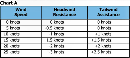
Thanks to Coast and Kayak magazine out of Nanaimo, BC for the following charts and information... and please note that because of stand up paddlers increased exposure while paddling upwind, speeds made while paddling are likely slower than that of kayakers.


"Wind has a profound effect on kayaks (and paddleboards). Obviously, a tailwind is going to help push a kayak on its way, while a headwind is going to slow it down. Chart A to the offers rough estimates of the effects that wind will have on the forward progress of a sea kayak.
Just as we’ve always suspected, a headwind slows us down more that a tailwind pushes us forward. Some things just aren’t fair! But bear in mind that a tailwind will generally also generate waves that will allow an experienced paddler to pick up surf rides, speeding him or her faster on their way than the push from the wind alone could generate.
Different paddlers counsel different strategies for dealing with a headwind. One old chestnut is to slow down and “conserve energy” for what will be a long arduous slog. Let’s do a little math and see what numbers we get.
If you look at Chart B, you can see slowing down a mere ½ knot to “conserve energy” will slow us down quite a bit. With 15 knots of headwind, if we slow down from three knots to 2.5 knots, our actual speed across the water (or “speed made good”) will be approximately one nautical mile per hour. That means that to cover six miles, it will take six hours. Conversely, if we paddle at 3.5 knots, speeding up a half knot from three, we’ll achieve a speed made good closer to two knots. This will put us in camp in three hours, or exactly half the time it took paddling at 2.5 knots.
So the question posed is: who has conserved more energy? One paddler will poke along for six hours. The other will paddle aggressively for three, put up a tent, have a meal, and maybe even take a little nap before the first paddler even arrives.
You decide – plug in different numbers to the table and see what kind of times will be generated by putting in different distances, winds and cruising speeds. You’ll find that when the wind blows in your face, it is almost always better to respond by paddling aggressively, rather than slowing down. The same is true for currents, or any other conditions that may slow your progress.
Clearly, you don’t want to exhaust yourself, but an increase, or decrease in speed of a mere half knot will make a very big difference to the overall time you spend on the water. So sometimes you’ll want to work harder in order to save energy in the long term. Other times, a little math may quickly convince you that avoiding strong headwinds altogether (in favour of staying ashore or modifying your planned route) is by far your best option."

Sunday, August 12, 2012

Squaxin Revisited

Made another trip around Squaxin Island, with far more pleasant conditions yesterday than the last time I was out. We were able to see more of the growing bull kelp forest, which is a beautiful sight, in part because for reasons unknown to me, it just never really developed last year. Many kelp crabs were clinging to the kelp. Also saw more harbor porpoises between Tucksel Point and Briscoe Point. Just a great paddle in some beautiful, clear blue-green waters.

Tucksel Point
Bull Kelp
Confluence of Peale and Pickering Passages
Salmon point
Pickering Passage
Are carbon paddles supposed to flex this much?
This boat should've been named 'Seen Better Days' - Palela Bay
A favorite sand and shell spit of mine, just east of Hope Island
Looking back at Potlatch Point
Hope and Steamboat Islands in calmer waters
Finishing the circumnavigation - the kelp forest at Tucksel Point

Saturday, August 11, 2012

Charismatic Macrofauna, or Where the Whales Are

Some of us naively dream of paddling with large aquatic mammals. Others would be happy just to see a porpoise or whale breeching in the distance. In most cases, unless you're spending a lot of time on the water in the San Juans or Gulf Islands, one of the few ways to stack the odds of spotting a whale or porpoise in your favor is to see where marine mammals have recently been sighted. The Orca Network is a nonprofit organization that is dedicated to raising awareness about the whales of the Pacific Northwest.  Their website has a recent sightings map, which allows you to see where and when recent sightings in the Salish Sea have occurred, as well as news, natural history, and photos. 

It's important to note that NOAA's Fisheries Service estimates there are currently only 86 orca whales that are residents of Washington waters. Remember that no vessels may approach whales within 200 yards and vessels are forbidden from intercepting or positioning in a whale's path. This includes not only motor boats, but also sailboats and kayaks, and by default, standup paddleboards. 

Thursday, August 9, 2012

When the Tide Is Right

Whereas tide charts note the vertical rise and fall of water, tidal current charts describe the horizontal flow of water with respect to the rise and fall of tides. I can’t overstress the importance of understanding how to read and predict tidal currents.

In a previous post, I discussed the Rule of Thirds and how to calculate currents' velocities. Once you have a better understanding and representation of the tidal currents' speeds and times for a given area, you have an improved understanding of what to expect...

Tidal 'River' in British Columbia
Tidal rips are disturbances in the water’s surface (and deeper) and make take the form of fast moving water, whirlpools, standing waves, and uneven surfaces. Though few tidal rips in the Puget Sound region are extreme (Deception Pass is an exception), other places in the world, including passages within British Columbia, have some very dangerous tidal rivers of water.

Tidal Rips in Dana Passage
There are many underwater causes for tidal rips and it is often the underwater terrain, or bathymetry, that determines the flow and movement of tidal currents. Underwater channels often allow a large amount of water to move quickly, often more quickly than the surrounding water, creating the appearance of a river of water. When flooding tidal currents reach underwater shelves or walls they often rise upwards, causing upwelling on the surface. These shelves can also create the appearance of currents as rollers as they become more pronounced when reaching shallower water. When a river or inlet meets another, they often create a clashing system, particularly when one current flows over another’s underwater channel. When several inlets converge in a single meeting place strange and unpredictable things tend to occur.

Sailboat Traveling in Eddy at Deception Pass
Eddy lines can occur near the edge of a tidal rip. They are often seen as water movement contrary to the tidal flow. Eddies are protected areas, often near the shoreline, that allow one to travel against the current’s flow. They are always unidirectional, in that they appear only during either a flood or ebb event, and often appear behind points or outcroppings on the shoreline. Eddies are very helpful when paddling against an opposing tidal current.

If the water's surface is smooth and you aren't quite sure which way the current is moving, easy ways to identify current directions include watching debris floating on the water or peering below the surface to observe the direction of bent and waving vegetation.

Tidal rips typically last until the next slack tide. Slack tides vary in duration, and their duration is often inversely related to the increasing speed of the currents before and after them. So the stronger the tidal current, the shorter the slack time. Stronger currents are typical during spring tides, which are associated with days surrounding new and full moons.

To negotiate rip currents, you must first always consider your ability level. If you question your ability to traverse or run a tidal rip, wait, in time the tidal current will diminish for safer travel. Other tips include staying upright on your board with soft knees and keeping a rapid, almost explosive, but controlled shortened paddle stroke. Be prepared to experience things you might not normally feel on the water, like a rip grabbing your fin and starting to spin you round. Another surprise is paddling through a period of rough, whitewater conditions and then reaching a flat, almost bulging, calm section of upwelling. Or finding that you have to paddle extremely hard to cover 25 feet.

Like so many things, controlled exposure to different tidal currents will help you build your confidence and experience with them. 

Tuesday, August 7, 2012

Know Before You Go; Pt. 5 - Wind Scale

In strong winds, stand up paddlers are essentially parachutes. But like fish stories, paddlers' experiences with wind speed grows over time and with each story. Many of us simply lack the experience and reference points that allow us to understand the conditions we are paddling in. 

Created in 1805, the Beaufort Scale is a tool that allows one to compare wind speed to conditions both on the water and on land. When checking wind speed before paddling, it helps you understand what to expect. And when you are out on the water, by relating to sea and land conditions, it gives you an idea of the wind speed you are paddling in. When it comes to windy conditions, having an empirical scale helps you understand your comfort level and limits.